Mapping Xinjiang: A Mongol-Banner Cartographer and the Qing Geographic Knowledge of Central Eurasia in the Late Eighteenth Century
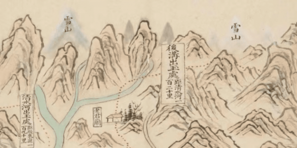
The Institute of History and Philology at Academia Sinica collects a huge map of Xinjiang made by a Qing Mongolian banner officer called Suningga in 1773. As the only existing copy in the world, this colorful manuscript map has plentiful cultural and heritage values. Additionally, it also contains significant historical meanings in providing abundant pictorial and literary information on Xinjiang under the rule of the Qing dynasty in the late eighteenth century. Namely, this map source is an invaluable resource in studying the history and the Qing and Xinjiang, especially Qing geographic of the so-called Xiyu (China’s western regions) and Qing infrastructure’s influence on Xinjiang’s landscape. The map meticulously illustrates the natural and human landscape of South Xinjiang, especially the infrastructure and social situation of Altishahr after the Qing conquest of the Zunghars. It should be noted that this map contains voluminous preface and postscript in which Suningga elaborated on the making process of the map based on his military experience in Xinjiang in the 1760s. His writings profoundly shed light on the interactions between diverse knowledge traditions including Song-Ming geomancy, Qing historical and geographic studies of Northwest China, and Islamic geography from Central Asia. Moreover, the map centering on Xinjiang contains extensive geographic records that profoundly reflects the author’s geographic understanding of the Tianxia. In addition to studying the history and geography of Xinjiang, these records provide critical clues to understand the diversity of cartography, geography, and worldview in the Qing empire. By contextualizing the map’s cartographic images and literary annotations together with related Qing records in Manchu and Chinese, the speaker investigates the development of Qing geographic knowledge of the Xiyu and Qing infrastructure’ influence on Xinjiang’s landscape, starting from the interactive perspective of late imperial China and Central Eurasia in the eighteenth century. Finally, based on historical and philological studies on the Qing map, the speaker has reconstructed the Qing traffic route of South Xinjiang by mapping it in a geographic information system (GIS).
Registration is required to attend the lecture. Once registered you will receive the Zoom link.
Supported by a gift from Leung Tung Peter & Lin Young.

